Shenandoah National Park
Trip Assistant
How Much Time?
Shenandoah is another park where you could zip through in a few hours, enjoying a few overlooks and a short trail or two, or spend a week, getting deeper into the mountains, enjoying picturesque waterfalls and craggy mountains. Most visitors only make a quick stop.
If you like to hike, Old Rag should be at the top of your list. It’s good and it’s popular, requiring a day-use pass during peak season.
After that, it’s off to Skyline Drive. The park offers an interesting combination of hiking and history. Try to take in a little of each. Mill Prong (which can be looped with Laurel Prong) to Rapidan Camp and Snead Farm Loop are good choices for history. Riprap/Wildcat Ridge Loop and Overall Run Falls or Little Devil’s Stairs are good choices for scenery.
Two nights feels like enough time here, then see some other things in the area including Washington, D.C.
Need to Know
- Reservations are required to hike Old Rag during peak season.
- Reservations are required for camping.
- Visitation peaks in October for fall foliage, but it’s pretty heavy from May through November.
- Being close to Washington, D.C., a mid-week trip is a very good idea.
- Rapidan Camp (Hoover’s summer White House) is only accessible during ranger-guided tours. However, you can hike to it any time via Mill Prong Trail (4 miles).
Highlights
- Skyline Drive
- Hazletop Ridge Overlook (mile 54.5)
- The Point Overlook (mile 55.5)
- Pinnacles Overlook (mile 35)
- Thorofare Mtn Overlook (mile 40.5)
- Dickey Ridge Visitor Center
- Rapidan Camp
- Fall foliage
Activities
- Hiking
- Backpacking
- Rock Climbing
- Horseback Riding
- Fishing
- Birdwatching
Favorite Trails
Easy
Moderate Strenuous Extreme *Links to AllTrailsWhen To Go?
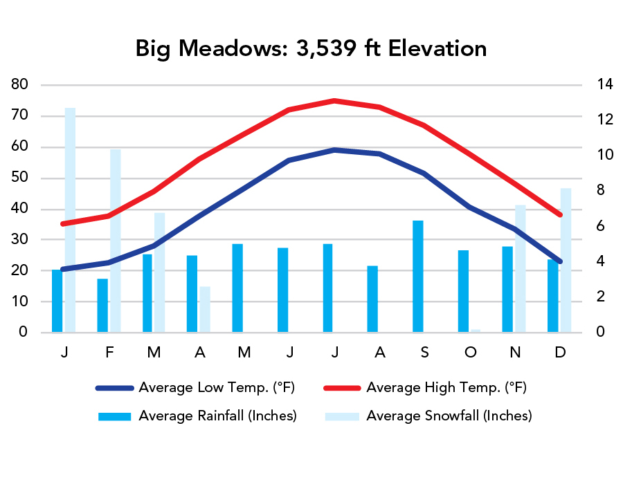
Weather
Visitation
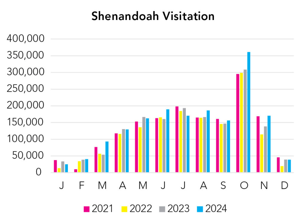
The park is quite busy from March through November, peaking in October for fall foliage. There’s more than 500 miles of hiking trails, making it easy to escape the crowds, but a mid-week trip is still advised.
Park Map Downloads
Road Trips
Helpful Tools
Below you'll see a Google Map to help plan road trips from the east (Washington, D.C.), north (Cuyahoga Valley), west (New River Gorge), and south (Asheville). It’s a good start, but I’d highly recommend making your own. Google My Maps, Wanderlog, Roadtrippers, and TripIt are incredibly useful trip planning tools. Find what works best for you!
There’s much more to our country. Here’s another Google Map with points of interest across all types of public land.
For campers, here’s a Google Map with National Forest campgrounds. National Park campgrounds are difficult to reserve (there are about 200!). With nearly 5,000 national forest campgrounds, you can usually pull in and find a spot.
If you like this, please check out my books or Buy Me a Coffee (more likely some fuel 🙂