Badlands National Park
Trip Assistant
How Much Time?
There’s only about 10 miles of hiking trails here and Badlands Loop Road is about 40 miles. So, it’s possible to hike all the official trails and drive the paved road in a day. Is that a good idea? Possibly. The thing is, this place is really pretty, and you really want to be here for a couple sunrises and sunsets, and get a little off the beaten path. Sage Creek Rim Road is fantastic, a great place for spotting wildlife. With a high-clearance 4x4 you can drive up Sheep Mountain Table, which provides some spectacular views (although it’s gotten awfully rutted up up there over the years). And then you can get a good of badlands relatively few visitors see by heading over to Red Shirt Table, which also sets you up nicely to get to Wind Cave National Park and Custer State Park.
Need to Know
- Making a quick detour from I-90, driving Badlands Loop Road will take about an hour.
- Almost everyone visits in summer, but summer is very hot.
- There’s quite a bit more to see and do. Some really great trails and lots of fantastic overlooks and wildlife.
- If the campgrounds are full, you can camp for free on Forest Service land north of Pinnacles Entrance.
Highlights
- Badlands Loop Road
- Castle
- Big Badlands Overlook
- Hay Butte Overlook
- Roberts Prairie Dog Town
- Sage Creek Rim Road
- Sheep Mountain Table
- Red Shirt Table Overlook
- Panorama Point
- Pinnacles Overlook
- Fossil Exhibit
- White River Valley Overlook
Activities
- Hiking
- Biking
- Horseback Riding
- Stargazing
Favorite Trails
Easy
Moderate Strenuous *Links to AllTrailsWhen To Go?
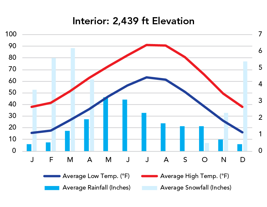
Weather
Visitation
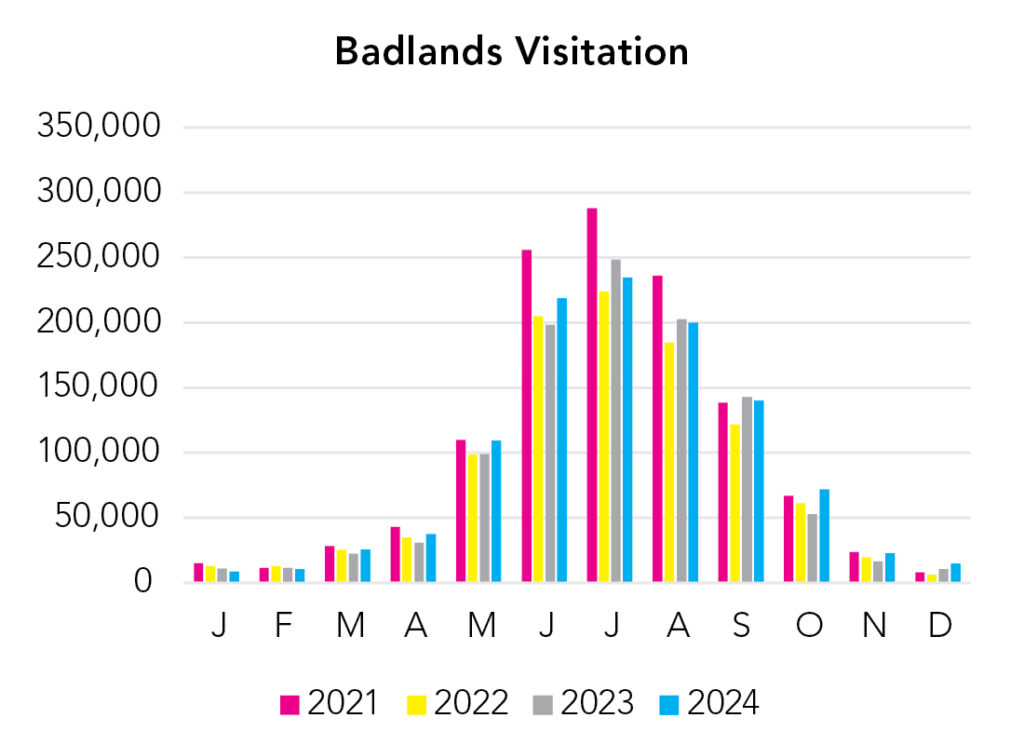
Summer is by far the busiest time of the year and it gets hot. Consider spring or fall for smaller crowds and better weather.
Park Map Downloads
Road Trips
Helpful Tools
Below you'll see a Google Map to help plan road trips from the east (Milwaukee, WI), north (Theodore Roosevelt), west (Wind Cave), and south (Scott's Bluff NM). It’s a good start, but I’d highly recommend making your own. Google My Maps, Wanderlog, Roadtrippers, and TripIt are incredibly useful trip planning tools. Find what works best for you!
There’s much more to our country. Here’s another Google Map with points of interest across all types of public land.
For campers, here’s a Google Map with National Forest campgrounds. National Park campgrounds are difficult to reserve (there are about 200!). With nearly 5,000 national forest campgrounds, you can usually pull in and find a spot.
Highlights
- Toadstool Geological Park (NE) (Oglala National Forest)
If you like this, please check out my books or Buy Me a Coffee (more likely some fuel 🙂