Big Bend National Park
Trip Assistant
How Much Time?
It takes some effort to get here, so you ought to plan on sticking around for a while! If it’s summer, you want to hang out in the Chisos Mountains, exploring the South Rim.
Hit the highlights. Regardless when you visit, the Chisos Mountains area should be priority 1. Then move on to the canyons on each end of the park. Mix in Mariscal too, if you have a 4x4. And, i fthat’s the case and you don’t mind primitive camping, consider giving it a go. There are some fantastic sites here. And you’ll experience some of the country’s darkest skies!
It wouldn’t be difficult to spend an enjoyable week hiking here. Big Bend Ranch State Park is worth checking out too. And then you can go across the border into Mexico.
Need to Know
- Reservations are required for campsites (except a handful of primitive roadside campsites).
- Come prepared. There’s a gas station and camp stores in the park, but you really want to bring everything you need.
- This is an excellent off-roading park. Here, you really need to be prepared! Be ready for self-rescue or have a reliable communication device. A tow will cost you some serious $!
Highlights
- Chisos Mountains
- Santa Elena Canyon
- Boquillas Canyon
- Primitive Roadside Campsites
- Ross Maxwell Scenic Drive
- Old Maverick Road
- River Road (4x4)
Activities
- Hiking
- Backpacking
- Biking
- Paddling/Rafting
- Stargazing
- Birdwatching
Favorite Trails
Easy
Moderate Strenuous *Links to AllTrailsWhen To Go?
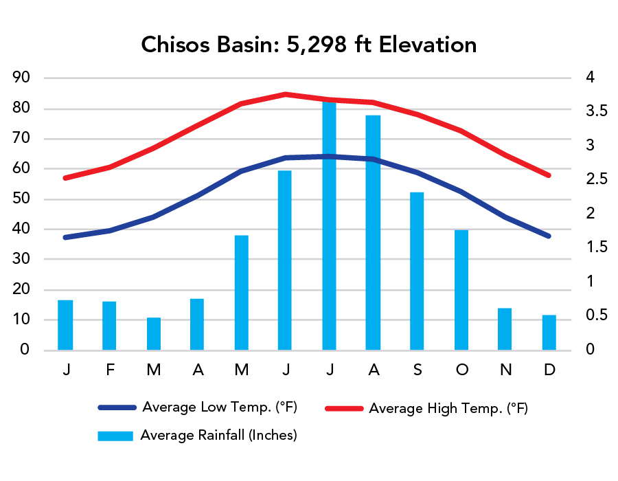
Weather
Visitation
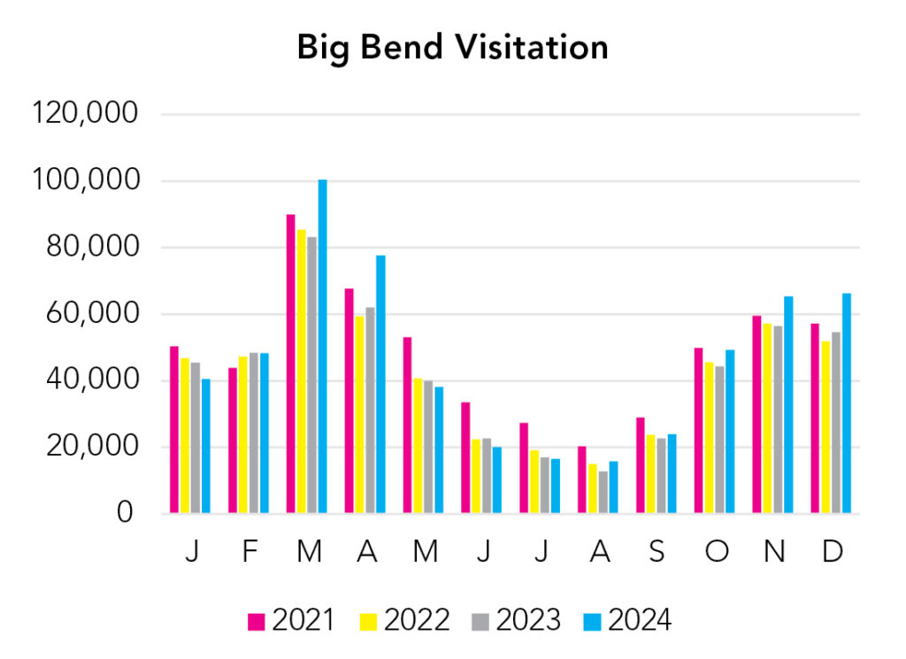
Summer can be decent in the Chisos Mountains. But remember temperature decreases about 3-5°F with every feet of elevation gain. There’s about a 4,000 foot difference between Chisos Basin and Rio Grande Village. Spring Break and winter holidays are busy. The rest of the year is very manageable. Most of the congestion occurs along Chisos Basin Road.
Park Map Downloads
Road Trips
Helpful Tools
Below you'll see a Google Map to help plan road trips from the east (Houston, TX), north (Carlsbad Caverns), and west (El Paso, TX). It’s a good start, but I’d highly recommend making your own. Google My Maps, Wanderlog, Roadtrippers, and TripIt are incredibly useful trip planning tools. Find what works best for you!
There’s much more to our country. Here’s another Google Map with points of interest across all types of public land.
For campers, here’s a Google Map with National Forest campgrounds. National Park campgrounds are difficult to reserve (there are about 200!). With nearly 5,000 national forest campgrounds, you can usually pull in and find a spot.
Highlights
South Padre Island and Starbase, TX (if there’s a rocket launch) are worth considering, but it’s a drive.
If you like this, please check out my books or Buy Me a Coffee (more likely some fuel 🙂