Black Canyon of the Gunnison National Park
Trip Assistant
How Much Time?
The answer is not much. But you should at least take the time to stop at both rims. The North Rim is fanatstic and much more peaceful than the south.
At the South Rim, drive the road, stop at some viewpoints (Gunnison Point, Chasm View, Painted Wall, and Cedar Point are really nice, but they’re all good), and then make the quick hike to Warner Point.
At the North Rim, do the short Chasm View hike, and then drive the road stopping at Narrows View, and the end of the road to get a good look at Kneeling Camel at a minimum. The hike to Exclamation Point is also good.
If you’re looking for something more thrilling, then pick an inner canyon trail or two. Just know, you must have a permit to do them.
Need to Know
- South Rim is open year-round, but South Rim Road closes beyond Gunnison Point in winter.
- East Portal and North Rim close for winter.
- North Rim Road is unpaved but (typically) very nice. The drive there from the south via CO-92 is extremely scenic.
- Inner canyon hiking is thrilling but dangerous (steep with loose rock, and possibly poison ivy). A permit is required. Reserve online for the South Rim. Sign up in-person at the North Rim Ranger Station.
Highlights
- Painted Wall
- Gunnison Point (South Rim)
- Kneeling Camel (North Rim)
- Painted Wall View (South Rim)
- The Narrows (North Rim)
- South Rim Road
- North Rim Road
- East Portal
Activities
- Hiking
- Backpacking
- Kayaking
- Rock Climbing
- Biking
- Horseback Riding
- Cross-country
- Snowshoeing
Favorite Trails
Moderate
Extreme (Inner Canyon) *Links to AllTrailsWhen To Go?
Weather

Visitation
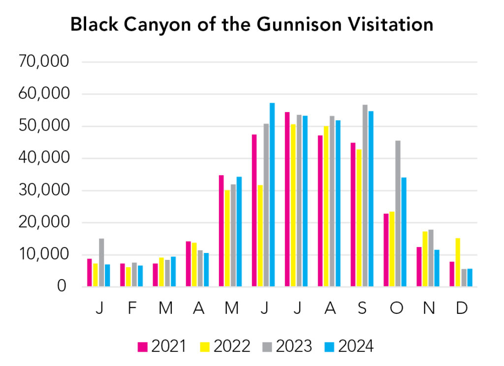
The North Rim and El Portal close for winter, as does South Rim Road beyond Gunnison Point. Snow on the rim and surrounding mountains definitely enhances the experience, but you best be comfortable driving in snowy/icy conditions. Summer is busy, but the traffic churns pretty quickly, with most visitors driving South Rim Road, stopping at a few viewpoints and moving on.
Park Map Downloads
Road Trips
Helpful Tools
Below you'll see a Google Map to help plan road trips from the east (Great Sand Dunes), north (Rocky Mountain), west (Arches), and south (Petrified Forest). It’s a good start, but I’d highly recommend making your own. Google My Maps, Wanderlog, Roadtrippers, and TripIt are incredibly useful trip planning tools. Find what works best for you!
There’s much more to our country. Here’s another Google Map with points of interest across all types of public land.
For campers, here’s a Google Map with National Forest campgrounds. National Park campgrounds are difficult to reserve (there are about 200!). With nearly 5,000 national forest campgrounds, you can usually pull in and find a spot.
Highlights
There’s a lot. This might be the prettiest part of the Lower 48 and I only know a tiny fraction of what there is to see and do over here, so spend some time gathering more information.
- Monarch Lake (CO)
- Maroon Bells (CO)
- Ice Lake/Island Lake (CO)
- Blue Lakes/Mount Sneffels (CO)
(This one is in Arapaho National Forest, just south of Rocky Mountain National Park. It's much easier to reach the stars of the area like Lake Isabelle from the other side of the Rockies via Long Lake Trailhead. It's definitely worth a look.)
(It's an iconic mountain setting, but also an expensive walk or photo-op if you park and take the shuttle--both require a fee. Parking at the trailhead also requires a fee and reservations. It's popular. There's no perfect solution to these things. BUT, there are a ton of hikes in the area. Use an app or scroll around Google Maps and choose what's right for you.)
(This trail is in the San Juan Mountains and accessed from a dirt road off the Million Dollar Highway. The entire region is sublime. There's nearly 2,000 miles of hiking trails in San Juan National Forest alone. That's more than 5x the trail mileage you'll find in Rocky Mountain National Park. There's also an abundance of unpaved roads. Everything is high elevation. Be sure to acclimate. And, most importantly, enjoy!)
(Mount Sneffels is one of the more iconic Colorado peaks. It's a climb to get there and the trailhead requires a 4x4. If you can reach the trailhead, Blue Lakes is a wonderful place to spend the day.)
If you like this, please check out my books or Buy Me a Coffee (more likely some fuel 🙂