Canyonlands National Park
Trip Assistant
How Much Time?
If you’re just sightseeing, a quick trip to Island in the Sky might be all you need. Just be warned, there can be a very long line of cars at the entrance in the middle of the day during peak season.
Now, if you like to hike, backpack, 4x4, and/or raft, you’re going to want to stick around for a while. The Maze is a 4x4/backpackers playground. Needles is the best hiking section. Island in the Sky offers a little bit of everything in addition to the most stunning, easily accessible views. While camping in the park is limited, there’s quite a bit of adjacent BLM land where you’ll find a few more options.
Need to Know
- Relative to the size of the park and number of visitors, there are very few campsites (and most of them are first-come, first-served!). It’s stupid.
- A permit is required for several 4x4 roads, including the popular White Rim Road. Fill up with gas before heading out on the dirt roads and be prepared for self rescue.
- Summers get quite hot during the middle of the day. Spring and fall tend to be the best times to visit, but winter can also be quite magical.
Highlights
Island in the Sky
- Green River Overlook
- Grand View
- Buck Canyon Overlook
- White Rim Road
- Exceptional Hiking
Activities
- Off-Roading
- Hiking
- Backpacking
- Biking
- Rafting
- Rock Climbing
- Horseback Riding
Favorite Trails
Easy
Moderate Strenuous *Links to AllTrailsWhen To Go?
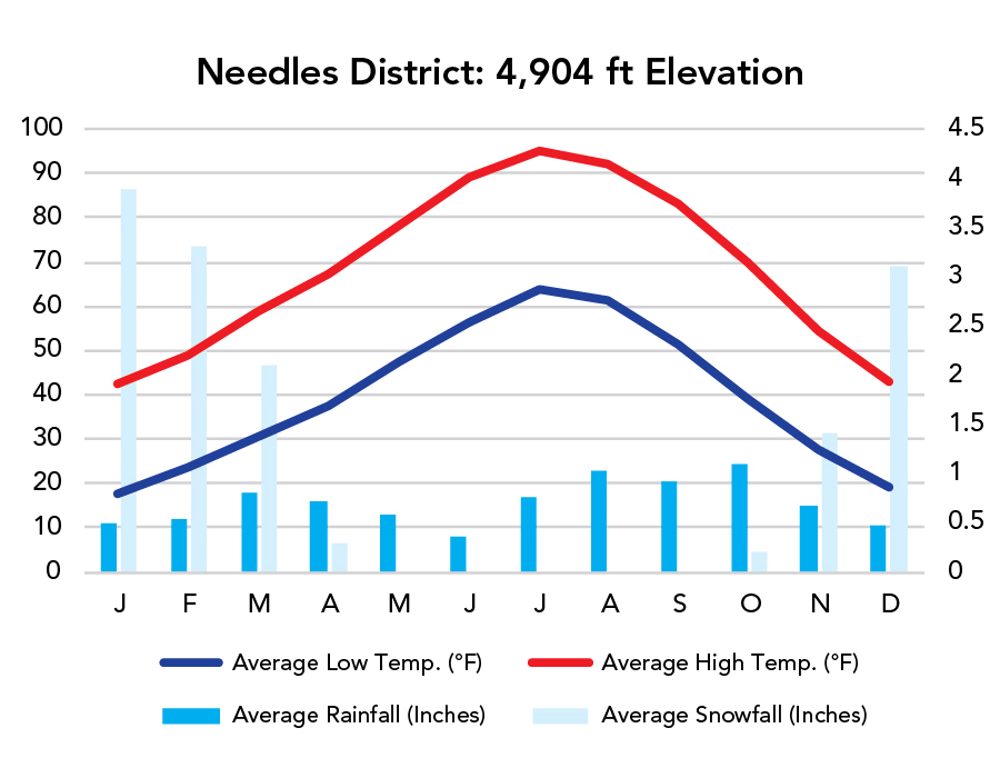
Weather
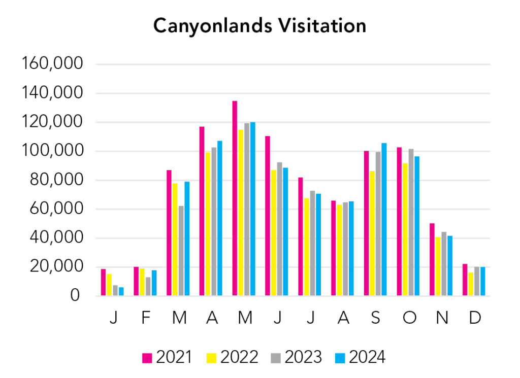
Visitation
Spring and fall are the best times to visit. Winter is mixed. Snow can make this place glorious, but it can also cause all sorts of headaches and dangerous situations. Summer gets hot and shade is fairly hard to come by, even with all those canyons :).
Park Map Downloads
Road Trips
Helpful Tools
Below you'll see a Google Map to help plan road trips from the east (Arches), north (Dinosaur National Monument & Uinta Mountains), west (Capitol Reef), and south (Petrified Forest). It’s a good start, but I’d highly recommend making your own. Google My Maps, Wanderlog, Roadtrippers, and TripIt are incredibly useful trip planning tools. Find what works best for you!
There’s much more to our country. Here’s another Google Map with points of interest across all types of public land.
For campers, here’s a Google Map with National Forest campgrounds. National Park campgrounds are difficult to reserve (there are about 200!). With nearly 5,000 national forest campgrounds, you can usually pull in and find a spot.
Highlights
UT-24 and UT-95 are littered with beautiful attractions!
If you like this, please check out my books or Buy Me a Coffee (more likely some fuel 🙂