Capitol Reef National Park
Trip Assistant
How Much Time?
I love this park! It offers a little something from each of the four other Utah National Parks with smaller crowds. The smaller crowds I suppose are because most of the best sites are accessed via unpaved roads. So, if you aren’t leaving pavement, it doesn’t take a whole heck of a lot of time to drive UT-24 (totally awesome) and scenic drive (and maybe hike something like Grand Wash and Chimney Rock/Spring Canyon). That would be an amazing day!
Now, if you’re vehicle is quite capable, you want to take Hartnet Road through Bentonite Hills to the tiny, two-car corral for Cathedral Valley Overlook. And do the full Cathedral Valley Loop (it gets a little hairy back by the primitive campground), and stop at Temple of the Sun and Moon too. Burr Trail is awesome and gets you to exciting trails like Upper Muley Twist. And then there are backpacking trips like Halls Creek Narrows, which I’m still itching to do.
Need to Know
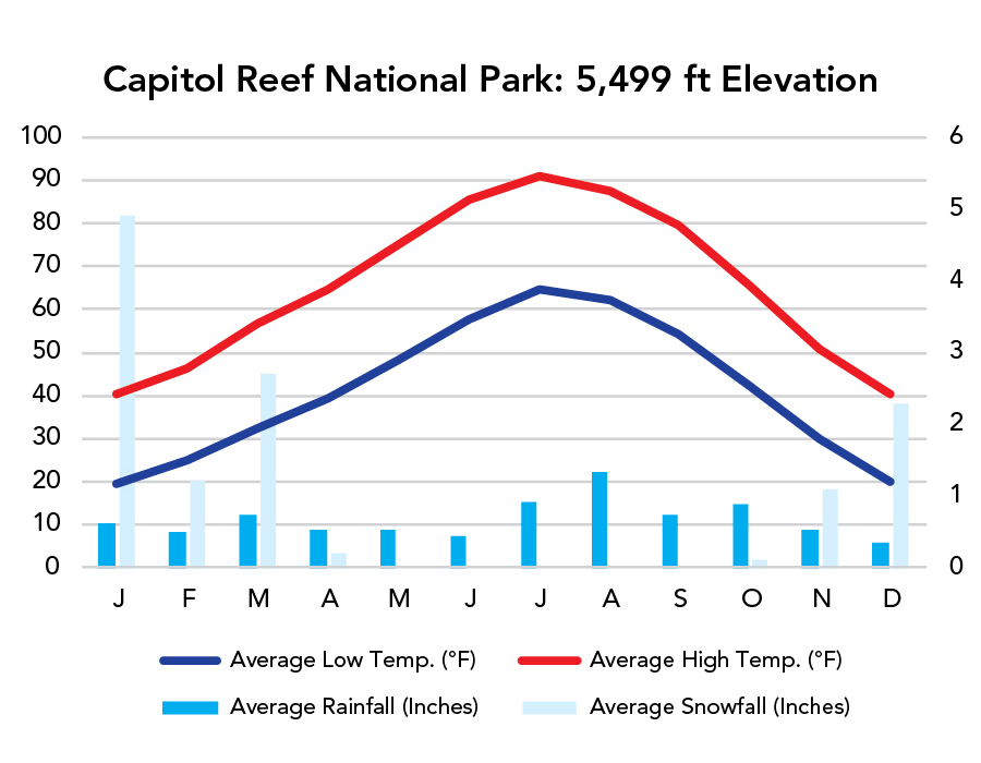
- Spring and fall tend to be the most comfortable seasons. Visit in summer, and you’ll want to stay in the slot canyons. It’ll be hot in the middle of the day. Winter can be nice.
- Before heading out on 4x4 roads, call (435) 425-3791 (press 1 then 4) for conditions.
Highlights
- UT-24
- Scenic Drive
- Temple of the Sun/Moon (4x4)
- Burr Trail (unpaved)
- Nottom-Bullfrog Road (unpaved)
- Bentonite Hills (North Blue Flats))
- Fruita
Activities
- Off-Roading
- Hiking
- Backpacking
- Biking
- Rock Climbing
- Canyoneering
- Horseback Riding
- Stargazing
Favorite Trails
Easy
Moderate- Lower Cathedral Valley Overlook
- Chimney Rock/Spring Canyon (out-and-back is fine)
- Golden Throne
- Cohab Canyon
- Hickman Bridge
- Headquarters Canyon
- Burro Wash (gets technical)
When To Go?
Weather
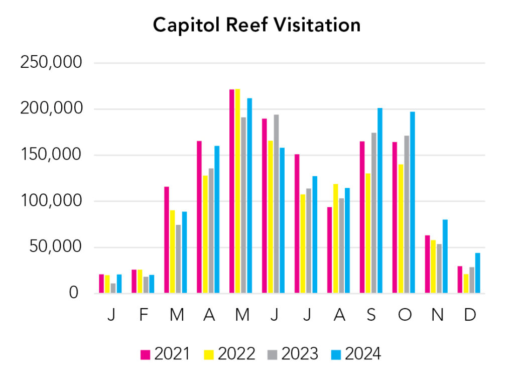
Visitation
In summer you’ll want to be exploring the park’s slot canyons. Spring and fall are great for off-roading and hiking. Winter can be unbelievably beautiful and daytime highs are usually above freezing, but snow is problematic on the dirt roads.
Park Map Downloads
Road Trips
Helpful Tools
Below you'll see a Google Map to help plan road trips from the east (Canyonlands), north (Uinta Mountains), west (Great Basin), and south (Bryce Canyon). It’s a good start, but I’d highly recommend making your own. Google My Maps, Wanderlog, Roadtrippers, and TripIt are incredibly useful trip planning tools. Find what works best for you!
There’s much more to our country. Here’s another Google Map with points of interest across all types of public land.
For campers, here’s a Google Map with National Forest campgrounds. National Park campgrounds are difficult to reserve (there are about 200!). With nearly 5,000 national forest campgrounds, you can usually pull in and find a spot.
Highlights
- Hole-in-the-Rock Road (Zebra, Peek-a-Boo, & Spooky slots, Jacob Hamblin Arch, Reflection Canyon, etc.) The only problem is Hole-in-the-Rock Road is unpaved and absolutely atrocious washboard. If you’re comfortable camping primatively, spend a few nights here.
- Lower Calf Creek Falls (UT)
- Boulder Mail Trail (UT)
If you like this, please check out my books or Buy Me a Coffee (more likely some fuel 🙂