Crater Lake National Park
Trip Assistant
How Much Time?
You don’t need much. Rim Drive is 33 miles. Garfield Peak and Watchman Overlook are the two must-hikes! And you should try to get tickets for a boat tour. If you’re a photographer, I could see sticking around for a couple nights to try and get an amazing sunrise/sunset shot. But, other than that, I’d be looking to move it along. There are a TON of incredible waterfalls in this area as well as lava tubes, and even some good whitewater rafting.
Need to Know
- Most roads and facilities are closed fall through spring.
- The road to Rim Village remains plowed through winter. And it’s pretty neat to see this place buried in snow.
- It’s a good idea to drive the rim clockwise. That way all the overlooks will be on your right.
Highlights
- West/East Rim Drive
- Sinnott Memorial Overlook
- Discovery Point
- Watchman Overlook
- Phantom Ship Overlook
- Vidae Falls
- The Pinnacles
Activities
- Hiking
- Backpacking
- Guided Tours
- Biking
- Fishing
- Swimming
- Cross-country Skiing
- Snowshoeing
Favorite Trails
Easy
Moderate Strenuous *Links to AllTrailsWhen To Go?
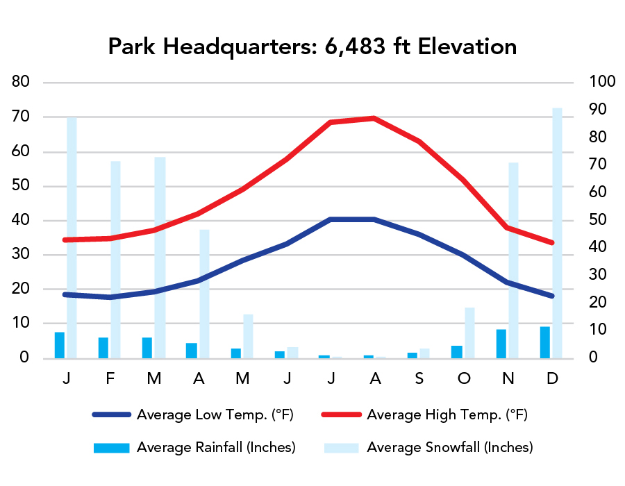
Weather
Visitation
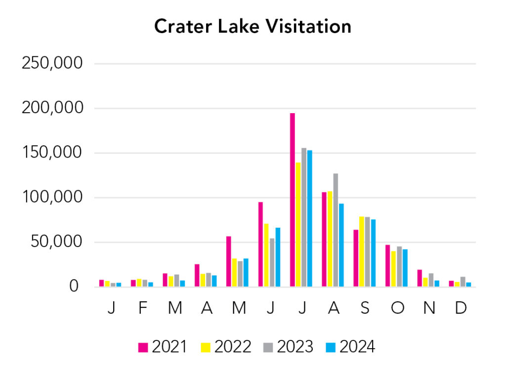
Visitation peaks in summer when Rim Drive fully opens, but you can reach Rim Village year-round. And there’s nothing quite like camping on this majestic lake’s Rim in spring when everything’s buried in snow but daytime highs are nice. It’s a lot of visitors in July for a relatively small area, but most people enter, drive the rim, and then leave. So, it isn’t quite as bad as the statistics suggest.
Park Map Downloads
Road Trips
Helpful Tools
Below you'll see a Google Map to help plan road trips from the east (West Yellowstone), north (Mount Rainier), west (Oregon Coast), and south (Lassen Volcanic). It’s a good start, but I’d highly recommend making your own. Google My Maps, Wanderlog, Roadtrippers, and TripIt are incredibly useful trip planning tools. Find what works best for you!
There’s much more to our country. Here’s another Google Map with points of interest across all types of public land.
For campers, here’s a Google Map with National Forest campgrounds. National Park campgrounds are difficult to reserve (there are about 200!). With nearly 5,000 national forest campgrounds, you can usually pull in and find a spot.
If you like this, please check out my books or Buy Me a Coffee (more likely some fuel 🙂