Cuyahoga Valley National Park
Trip Assistant
How Much Time?
Cuyahoga Valley can be a polarizing place among National Park enthusiasts. It’s small. It’s urban. It’s not the Rocky Mountains or Grand Canyon, but there is an awful lot to like here, and if you put in some effort, you’ll like it too.
If you want to make a quick trip, I get it. Spend a day doing the mandatory hikes (Blue Hen Falls, Brandywine Falls, and Ledges). There are a few other good non-National Park trails too, check out the Google Map. You might still have time to get on the train.
Add another day, and you should bike or hike Towpath Trail. There are some really nice stretches by Station Road Bridge, Ira, and Boston. Or use the train and bike/hike one-way (just make sure the depot you want to use is open, they close from time to time). And then check out Hale Farm & Village. You’ll definitely feel like you traveled back in time.
I’m not sure you’d need more time than that unless you’re going to check out the cities or catch a performance at Blossom Music Center or Porthouse Theatre.
Need to Know
- Located in Akron and near Cleveland, the park is busiest on weekends. Visit mid-week if possible.
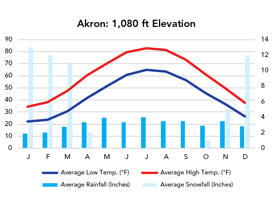
- Spring is great for waterfalls. Fall is fantastic for foliage. Winter can be wonderful but be prepared for cold and snow. Summer is when you can catch all the great performances at Blossom Music Center and Porthouse Theatre.
- To make the most of a trip here, you need to plan ahead, see what’s scheduled at Blossom Music Center, Porthouse Theatre, and Cuyahoga Valley Scenic Railroad.
Highlights
- Ledges
- Blue Hen Falls
- Brandywine Falls
- Cuyahoga Valley Scenic Railroad
- Station Road Bridge
- Towpath Trail
- Blossom Music Center
- Porthouse Theatre
- Hale Farm & Village
Activities
- Train Rides
- Hiking
- Biking
- Paddling
- Golfing
- Birdwatching
- Snow Sports
- Concerts/Theater Events
Favorite Trails
Easy
Moderate *Links to AllTrailsWhen To Go?
Weather
Visitation
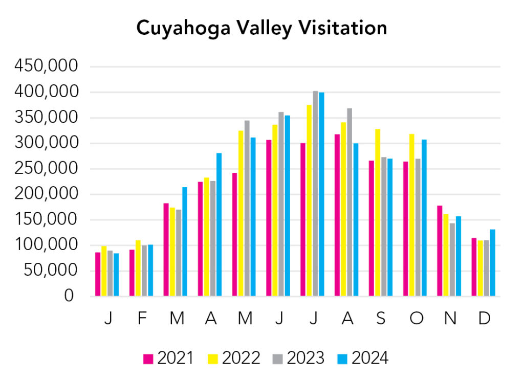
Weekends are busy, spring through fall. Spring is waterfall season. Summer is concert and theater season. Fall is foliage season.
Park Map Downloads
Road Trips
Helpful Tools
Below you'll see a Google Map to help plan road trips from the north (Michigan's Upper Peninsula), south (Mammoth Cave), east (Indiana Dunes), or east (Acadia). It’s a good start, but I’d highly recommend making your own. Google My Maps, Wanderlog, Roadtrippers, and TripIt are incredibly useful trip planning tools. Find what works best for you!
There’s much more to our country. Here’s another Google Map with points of interest across all types of public land.
For campers, here’s a Google Map with National Forest campgrounds. National Park campgrounds are difficult to reserve (there are about 200!). With nearly 5,000 national forest campgrounds, you can usually pull in and find a spot.
If you like this, please check out my books or Buy Me a Coffee (more likely some fuel 🙂