Glacier National Park
Trip Assistant
How Much Time?
How much time do you have? Even with more than half a million visitors per month from June through September, I could spend years hiking here and never tire of it. Non-hikers might feel differently.
I feel like three days is a minimum. Three days in Many Glacier alone probably won’t feel like enough, and you want at least a day to explore Going-to-the-Sun Road, another day at Two Medicine, and if you like backpacking or long dayhikers, another day spent along North Fork Road to do the semi-loop around Bowman and Kintla Lakes.
If you aren’t into backpacking, there are unique backcountry chalets from the railroad’s early days. Granite Park Chalet gets you close to scenic viewpoints like Grinnell Glacier Overlook and Swiftcurrent Lookout. Sperry Chalet gets you close to Sperry Glacier and Lake Ellen-Wilson/Gunsight Pass. People love this place. Get an early start or use the free park shuttle.
Need to Know
- Reservations are required for camping. (It’s not easy getting these sites.)
- Going-to-the-Sun Road typically opens fully in late June/early July, but there’s still a lot to do before that, and these mountains are even more magnificent covered in snow.
- US-2 is open year-round.
- Timed-Entry tickets are required for the west entrance of Going-to-the-Sun Road, North Fork Road, and Many Glacier (when it reopens fully in 2026).
- Timed-entry does not guarantee parking. Logan Pass typicall fills by 8am.
Highlights
- Many Glacier
- Two Medicine
- Going-to-the-Sun Road
- Lake McDonald
- St. Mary Lake
- Bowman Lake
- Kintla Lake
- Goat Haunt
Activities
- Hiking
- Backpacking
- Red Jammer Tours
- Boat Tours
- Fishing
- Horseback Riding
- Biking
- Cross-country Skiing
- Snowshoeing
Favorite Trails
Easy
- Redrock Falls
- Apikuni Falls
- St. Mary’s & Virginia Falls
- Running Eagle Falls
- Baring Falls
- Sun Point
- Aster Park
- Twin Falls
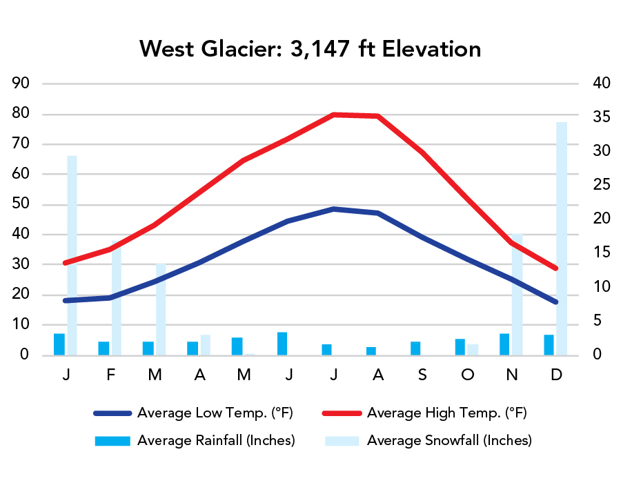
When To Go?
Weather
Visitation
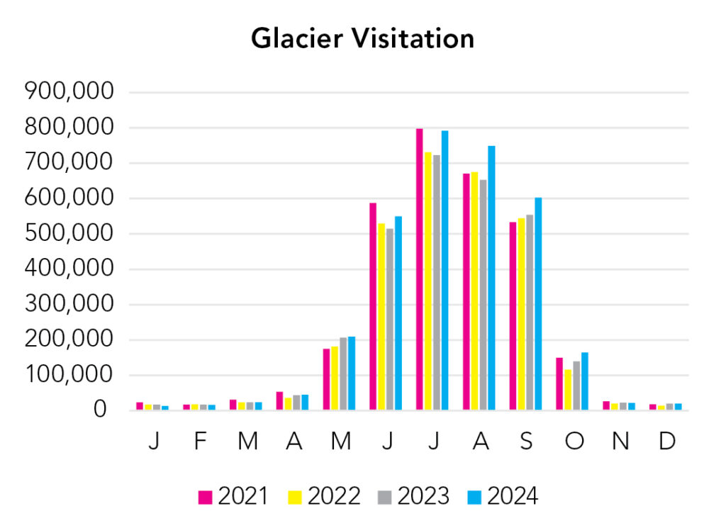
The park is expansive, but the crush of summer visitors causes a few problems (even with timed entry). People tend to congregate along Going-to-the-Sun Road and Many Glacier. An early start is recommended for both of these areas. A Timed-Entry Permit does not guarantee parking. Expect the parking lot at Logan Pass to fill by 8 or 9 am in summer. Parking at Avalanche Lake Trailhead is extremely competitive. Lines for the shuttle can be long too, but it is pretty efficient, and then you don’t have to deal with the stress of navigating a narrow, winding road. Offseason travel is an alternative. In spring, there’s a hiker/biker shuttle on the west side, ferrying visitors up Going-to-the-Sun Road as far as the it’s plowed. US-2 is open year-round. Weather is a little less predictable in October, but average nighttime lows remain above freezing in the lower elevations. And, as always, the best way to escape the crowds is to go on a long hike or backpack trip. This place is a hiker’s paradise. Come and enjoy it!
Park Map Downloads
Road Trips
Helpful Tools
Below you'll see a Google Map to help plan road trips from the east (Theodore Roosevelt), west (North Cascades), and south (Yellowstone). It’s a good start, but I’d highly recommend making your own. Google My Maps, Wanderlog, Roadtrippers, and TripIt are incredibly useful trip planning tools. Find what works best for you! (Will make the map once roads are open in summer.)
There’s much more to our country. Here’s another Google Map with points of interest across all types of public land.
For campers, here’s a Google Map with National Forest campgrounds. National Park campgrounds are difficult to reserve (there are about 200!). With nearly 5,000 national forest campgrounds, you can usually pull in and find a spot.
Highlights
Island Lake is found along the marvelous Beartooth Highway. I'd recommend camping at Island Lake over the nearby Beartooth Lake. East and West Rosebud Trailheads allow you to get further into the Beartooth Range. The entire area is really quite magical. There's more than a vacation's worth of activities to do right here. The Bitterrroot Mountains are a similar story. This range is seperated by several granite canyons. Some are surprisingly similar to Yosemite. If you'd like to see them from above. Hike to Trapper Peak, the tallest point in the park. If you'd like to stay closer to sea level, stay on a canyon's floor. There are more than a dozen canyon hikes to choose from. I'd start by looking in the area around Lake Como and Trapper Peak.
If you like this, please check out my books or Buy Me a Coffee (more likely some fuel 🙂