Grand Canyon National Park
Trip Assistant
How Much Time?
Just checking out viewpoints from Hermit’s Rest to Desert View on the South Rim takes a full day. If you want to head over to the North Rim (which you should—there are a few very special viewpoints over there and smaller crowds), that’s a four hour drive!
How much more time? Well, you can spend 20+ days rafting the entire canyon or several nights backpacking from rim-to-rim-to-rim. Even if you aren’t a big hiker or interested in any of the other activities, I’d suggest spending two nights on the South Rim and another night at the North Rim. It’s a very pretty place, and changes year-to-year, season-to-season, day-to-day, hour-to-hour. Enjoy a few sunrises and sunsets while you’re visiting this incredible creation of Mother Nature’s patient handiwork.
There is one problem. There’s a lot to see in this corner of the country. Be sure to check out this POI map and the suggested road trips below.
Need to Know
- Reservations are required for camping.
- South Rim is open year-round. North Rim closes for winter.
- Compared to the South Rim, it’s about 7°F cooler on the North Rim, and 20°F warmer at the canyon floor.
- There are four free shuttle routes at the South Rim.
- You don’t have to go Rim-to-Rim to have fun in the inner canyon. South Kaibab and Bright Angel are great as out-and-backs. Just turn around long before you’re tired.
- A 4x4 unlocks awesome places like Toroweap.
Highlights
- There are unlimited outstanding views here!
- South Rim: Yavapai Point, Lipan Point, Mohave Point, Desert View, Mather Point, Yaki Point, Hopi Point, Trailview Overlook
- North Rim: Toroweap Point, Cape Royal, Point Imperial, Point Sublime, Bright Angel Point
Activities
- Hiking
- Backpacking
- Mule Rides
- Biking
- Flightseeing
- Train Excursions
Favorite Trails
Easy
Moderate Strenuous *Links to AllTrailsWhen To Go?
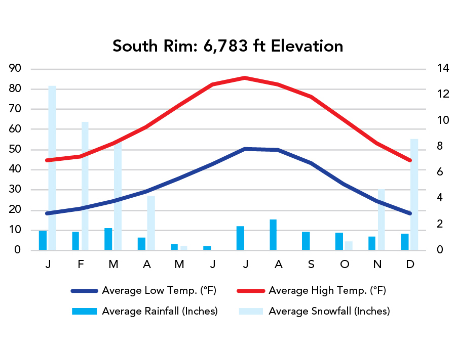
Weather
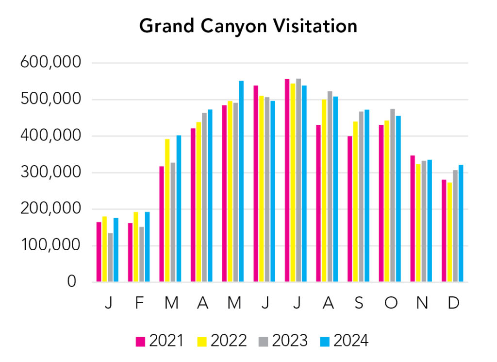
Visitation
The South Rim (~7,000 ft elevation) is open year-round, and stays fairly busy all year. The North Rim (~8,000 ft elevation) closes for winter. The canyon floor is around 2,500 feet elevation. Temperature drops 3-5°F with every 1,000 feet of elevation gain. Everyone says to go to the North Rim for a quieter experience, and that is mostly true, but there are very few visitor accommodations over there. Peace and quiet can be found at the South Rim by going for a walk. Snow on the canyon’s rim can be magical, but it can also be problematic for getting around (although it rarely lasts long).
Park Map Downloads
Road Trips
Helpful Tools
Below you'll see a Google Map to help plan road trips from the east (Petrified Forest), north (Zion), west (Las Vegas, NV), and south (Saguaro). It’s a good start, but I’d highly recommend making your own. Google My Maps, Wanderlog, Roadtrippers, and TripIt are incredibly useful trip planning tools. Find what works best for you!
There’s much more to our country. Here’s another Google Map with points of interest across all types of public land.
For campers, here’s a Google Map with National Forest campgrounds. National Park campgrounds are difficult to reserve (there are about 200!). With nearly 5,000 national forest campgrounds, you can usually pull in and find a spot.
Highlights
- Coral Pink Sand Dunes SP (UT)
- Lee’s Ferry (Glen Canyon NRA)
- Horseshoe Bend (AZ)
- Antelope Canyon (AZ)
- Glen Canyon/Lake Powell (AZ)
- Superstition Mountains (AZ) / (Tonto National Forest)
- Tonto Natural Bridge SP (AZ)
- Sedona (AZ) / (Coconino National Forest)
If you like this, please check out my books or Buy Me a Coffee (more likely some fuel 🙂