Great Sand Dunes National Park
Trip Assistant
How Much Time?
If you don’t have a 4x4, one day is plenty to explore the dunesfield. Although it is infinitely fascinating watching the play of shadows and light as we rotate around the sun.
If you’re hikers with a 4x4, then you think about driving Medano Pass Primitive Road. You should come prepared to air down your tires. It’s usually pretty sandy west of the dunes. There is an air pump near the start of the road by the RV dump station. There are primitive campsites along the road. You can also camp in the dunes, but you only want to do that on calm nights.
Need to Know
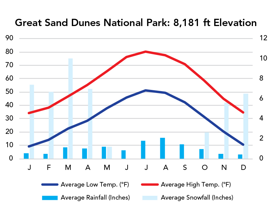
- Summer is the busiest. People come to relax in Medano Creek. But it’s also very hot. And even on a warm day you won’t want to walk barefoot in the sand. It’s scorching.
- You’ll be at elevation. Peaks rise above 13,000 feet, and the western lowlands remain above 7,500.
- Trails in the dunes aren’t marked. Follow footsteps, blaze your own, or come prepared with a track on your phone.
Highlights
- High Dune
- Star Dune
- Hidden Dune
- Sand Pit
- Medano Pass Primitive Road (4x4)
Activities
- Hiking
- Backpacking
- Sand Fun
- Biking
- Horseback Riding
Favorite Trails
Moderate
Strenuous *Links to AllTrailsWhen To Go?
Weather
Visitation
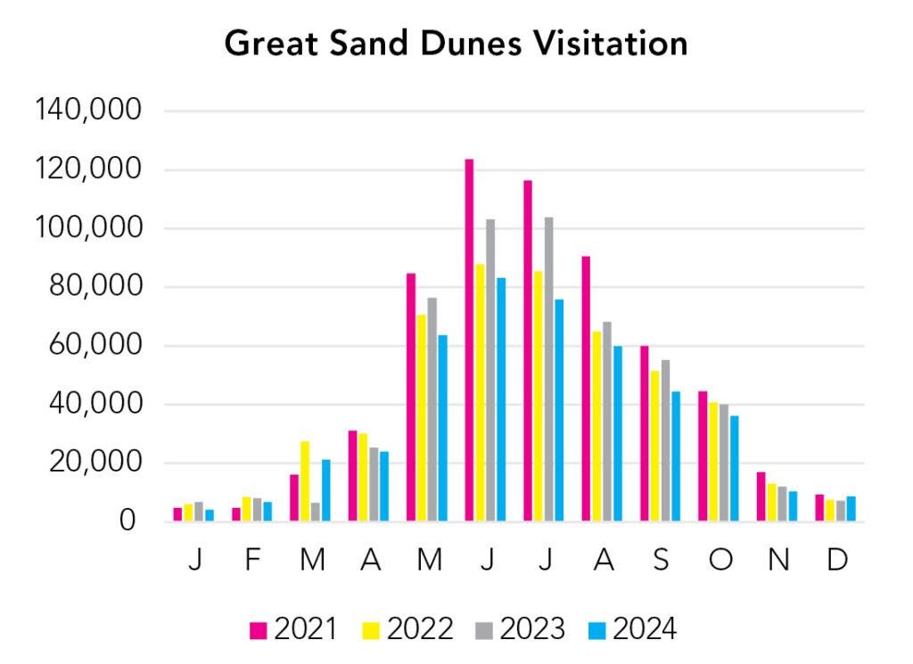
The park is relatively small and just about every visitor congregates in the High Dunes area, which causes some serious congestion in summer. Fortunately that isn’t the only good time to visit. April and October can be nice too. It’s just a little riskier, with chances of overnight snow. And remember, you’re at elevation here. Temperature decreases 3-5°F with every 1,000 feet of elevation gain.
Park Map Downloads
Road Trips
Helpful Tools
Below you'll see a Google Map to help plan road trips from the east (Oklahoma City, OK), north (Rocky Mountain), west (Black Canyon of the Gunnison), and south (White Sands). It’s a good start, but I’d highly recommend making your own. Google My Maps, Wanderlog, Roadtrippers, and TripIt are incredibly useful trip planning tools. Find what works best for you!
There’s much more to our country. Here’s another Google Map with points of interest across all types of public land.
For campers, here’s a Google Map with National Forest campgrounds. National Park campgrounds are difficult to reserve (there are about 200!). With nearly 5,000 national forest campgrounds, you can usually pull in and find a spot.
Highlights
There are some fantastic areas like The Million Dollar Highway and CO-149, which cut through San Juan National Forest. And Rio Grande and Uncompahgre National Forests aren’t too shabby either. There are a few suggestions of trails to hike in those areas on the Black Canyon of the Gunnison page. And there's plenty to see in this area, too.
Quandary Peak is considered an introductory 14er (it's still hard). Mount Elbert is the tallest peak in Colorado, and it's relatively easy too, but still more than one mile of elevation gain. You don't have to hike to summits. You can drive (or tram) to the top of Pike's Peak. And you can drive to the top of Mount Blue Sky (formerly Evans). Both require reservations during periods of peak visitation.
If you like this, please check out my books or Buy Me a Coffee (more likely some fuel 🙂