Gaudalupe Mountains National Park
Trip Assistant
How Much Time?
This little collection of National Parks (Guadalupe Mountains, Carlsbad Caverns, and White Sands) doesn’t require a ton of time. Here, if you enjoy hiking, you focus on Guadalupe Peak, Devil’s Hall, and Permian Reef (not necessarily in that order). McKittrick Canyon is good too. One night is what I do now. But, if you want to see each area, it takes more time. Salt Basin Dunes, Williams Ranch, Pine Springs, McKittrick Canyon, and Dog Canyon all have their own access roads, and take quite a bit of time just to reach, much less explore, even though the park isn’t all that big (considering you’re in Texas :). If you’re adding Big Bend to this trip, I’d maximize your time there, and do this with a little more haste.
Need to Know
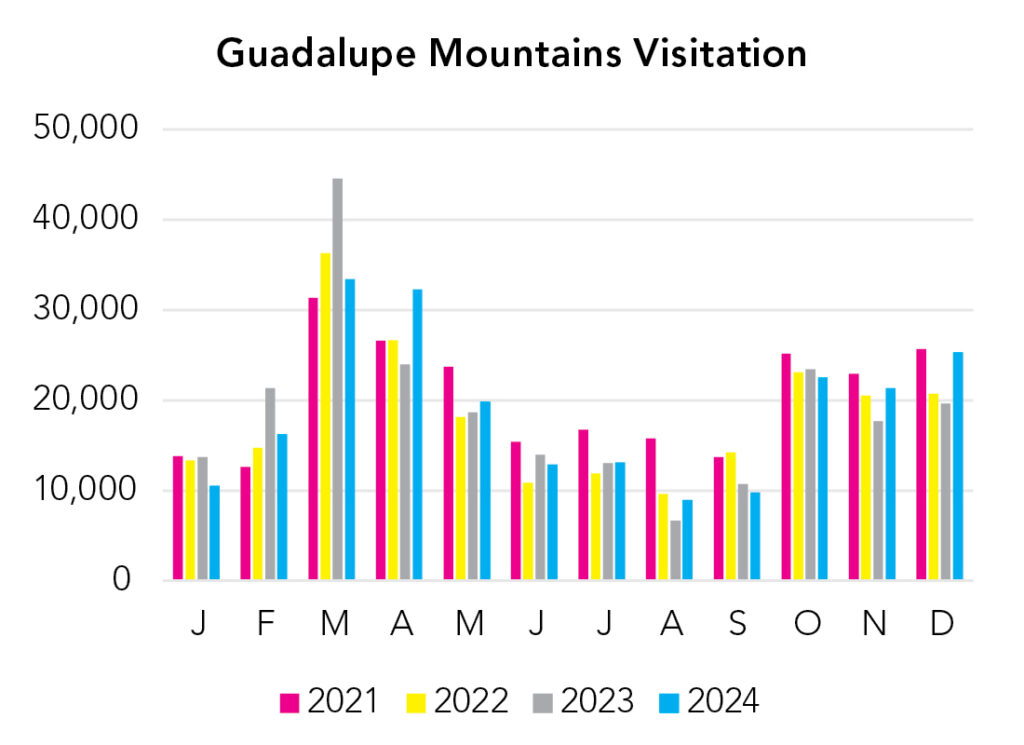
- It gets busy here around spring break and again in fall when leaves start to change.
- You need to get a key from the visitor center to drive to Williams Ranch (4x4).
- If you’re also going to White Sands while you’re out here (which is a very good idea), skip Salt Basin Dunes. It’s a long drive and usually very windy on that side of the mountain range. You’ll see plenty of white sand at White Sands.
Highlights
- McKittrick Canyon (Day-use only)
- Pine Springs
- Williams Ranch (4x4)
- Salt Basin Dunes (Day-use only)
- US-62 (there are some exceptional views and rest areas along the highway)
Activities
- Hiking
- Backpacking
- Stargazing
- Horseback Riding
Favorite Trails
Moderate
Strenuous *Links to AllTrailsWhen To Go?
Weather

Visitation
Remember temperature decreases about 3-5°F with every feet of elevation gain and Guadalupe Peak, the highest point in Texas, is more than 8,700 feet elevation. Dell City is 3,700 feet elevation. Texans come here to cool off in summer.
Park Map Downloads
Road Trips
Helpful Tools
Below you'll see a Google Map to help plan road trips from the northeast (Carlsbad Caverns), west (White Sands), and south (Big Bend). It’s a good start, but I’d highly recommend making your own. Google My Maps, Wanderlog, Roadtrippers, and TripIt are incredibly useful trip planning tools. Find what works best for you!
There’s much more to our country. Here’s another Google Map with points of interest across all types of public land.
For campers, here’s a Google Map with National Forest campgrounds. National Park campgrounds are difficult to reserve (there are about 200!). With nearly 5,000 national forest campgrounds, you can usually pull in and find a spot.
Highlights
Everyone in this area likes to say, “if you’re here, you’re here for the park.” It’s kind of true. The region is pretty desolate, but there’s oil and El Paso, and a few nearby attractions. And, twice a year you can tour the Trinity Site. There are some petroglyphs. Whether they’re by modern man or ancient man, I’m not sure.
If you like this, please check out my books or Buy Me a Coffee (more likely some fuel 🙂