Indiana Dunes National Park
Trip Assistant
How Much Time?
With a day, spend some time at West Beach (and hike Dune Succession Trail while there). Hike Cowle’s Bog and/or Paul H. Douglas trails. And then catch sunset from the waterfront. West Beach, Portage Lakefront, Lake View Beach are all good choices. It’s also a good idea to check out Indiana Dunes State Park, where you’re allowed to play in the dunes.
More time here, means more time on the beaches or daytrips to Chicago or South Bend. It’s also a good idea to check out the ranger programs. They have some creative offerings in summer! And then there are two destinations you can only explore with a ranger, Mount Baldy and Pinhook Bog. However, you can get a good view of Baldy and enjoy the beach from the hiking trail.
Need to Know
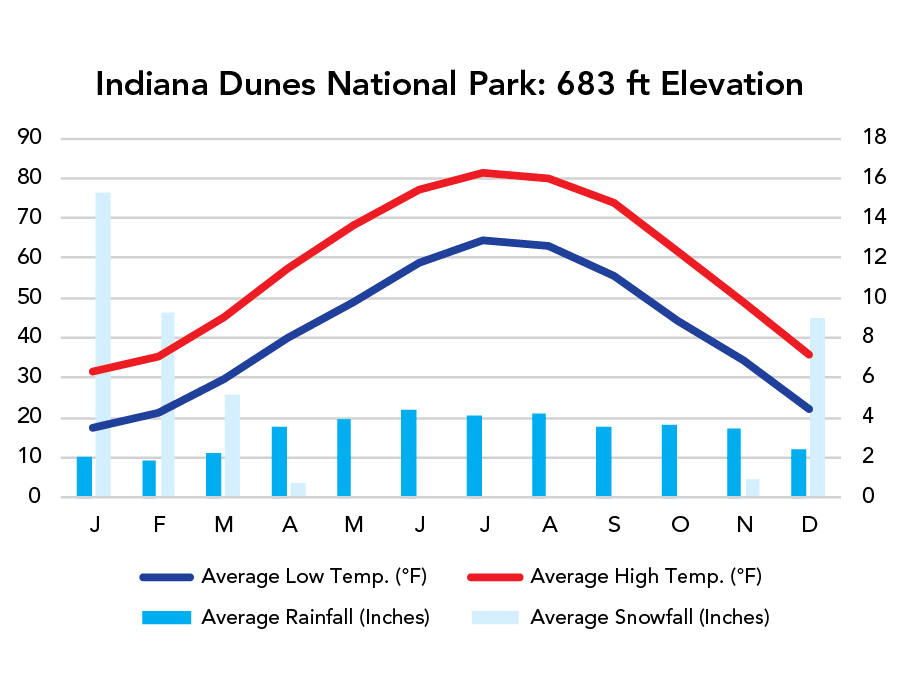
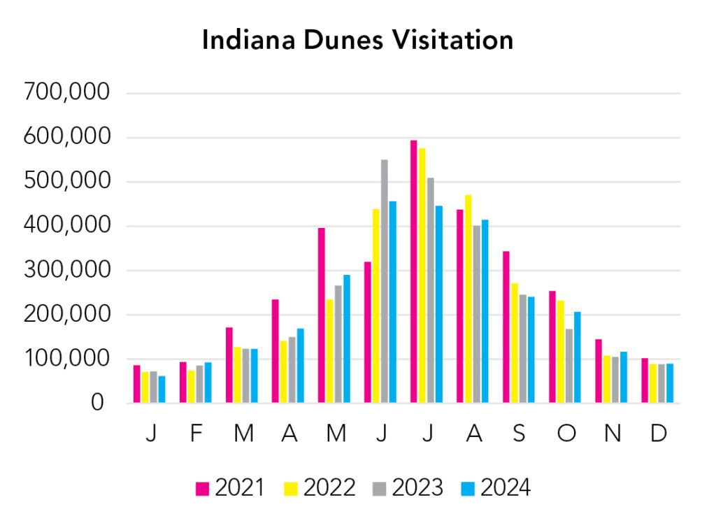
- About half of all visitors arrive in summer. Summer is nicest, and the only time you’ll want to play in the cool Lake Michigan water, but it’s far from the only good time to visit.
- The South Shore Line connects the park with Chicago and South Bend. While it’s not a particularly good idea to arrive here by train (the park is disjointed, making a vehicle nearly mandatory to explore it), but the train is a good option for a daytrip into Chicago.
Highlights
- West Beach
- Chellberg Farm
- Dunbar Beach
- Mount Baldy
- Pinhook Bog (Ranger Tours Only)
- Portage Lakefront
Activities
- Whitewater Rafting
- Rock Climbing
- Hiking
- Backpacking
- Biking
- Fishing
Favorite Trails
Easy
- West Beach (combines 3 trails)
- River Walk
When To Go?
Weather
Visitation
There are four seasons in the north. If you want to play in the water, summer is your only choice, but it’s busy. Leaves in fall. Peace in winter and spring.
Park Map Downloads
Road Trips
Helpful Tools
Below you'll see a Google Map to help plan road trips from the east (Cuyahoga Valley), north (Isle Royale), west (Gateway Arch), and south (Mammoth Cave). It’s a good start, but I’d highly recommend making your own. Google My Maps, Wanderlog, Roadtrippers, and TripIt are incredibly useful trip planning tools. Find what works best for you!
There’s much more to our country. Here’s another Google Map with points of interest across all types of public land.
For campers, here’s a Google Map with National Forest campgrounds. National Park campgrounds are difficult to reserve (there are about 200!). With nearly 5,000 national forest campgrounds, you can usually pull in and find a spot.
If you like this, please check out my books or Buy Me a Coffee (more likely some fuel 🙂