New River Gorge National Park
Trip Assistant
How Much Time?
The amount of time you’ll need here revolves around rafting trips. And, if you really love whitewater, you may want to plan around the short Gauley Rafting season (six weeks in September & October). Or come in spring when the Lower New will be nice and rowdy.
The park is small, but it takes some time to explore thoroughly because there are lots of regions and everything is disjointed. But in a full day, you could check out all the highlights (Grandview, Castle Rock, Long Point, Canyon Rim, New River Gorge Bridge, Fayette Station Road, and Endless Wall, and Sandstone Falls). But you might want to slow down a bit, enjoy Fayetteville, and some of the historic mining districts.
Spend another night to get back in the river, which is always a good idea. Mountain biking and rock climbing are good options. Or join in the multitude of activities offered at the rafting camps!
Need to Know
- Whitewater rafting is the big draw, but there’s quite a bit more to this park, including excellent hiking and rock climbing, scenic drives, and historical mining sites.
- The Upper New River is the easiest run (Class I-III). The Lower New is splashier (two Class IV+ rapids). The Gauley is for experienced paddlers.
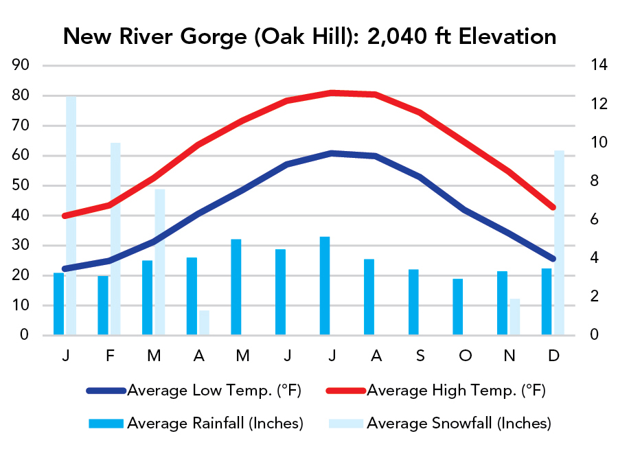
- The New River flows from south to north, providing uncommonly warm water. It’s usually about 70s°F by July!
- Bridge Day is in mid-October. People jump off the bridge!
Highlights
- Rafting the New River
- Rafting the Gauley River
- Canyon Rim Visitor Center
- New River Gorge Bridge
- Fayette Station Road
- Grandview Overlook
- Sandstone Falls
- Thurmond
- Nuttallburg
Activities
- Whitewater Rafting
- Rock Climbing
- Hiking
- Backpacking
- Biking
- Fishing
Favorite Trails
Easy
Moderate Strenuous *Links to AllTrailsWhen To Go?
Weather
Visitation
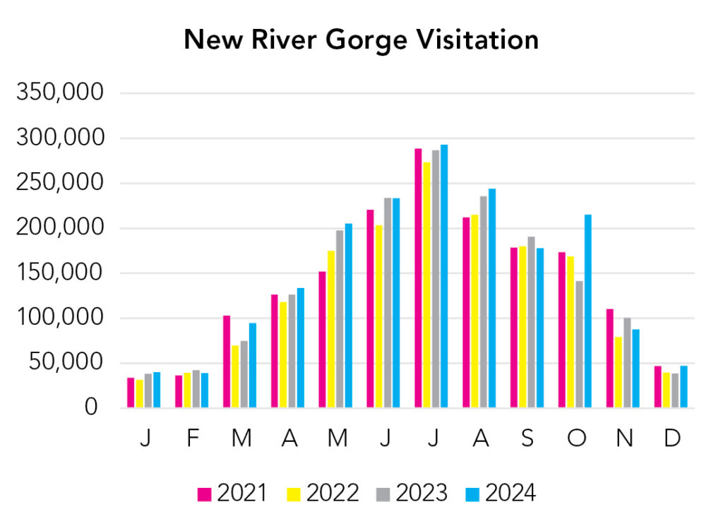
While there are plenty of reasons to visit New River Gorge, if this is your one-and-only time, you ought to be rafting! Spring the Lower New gets rowdy. Summer the water calms down and warms up. Fall is the short Gauley season (6 weeks in September/October).
Park Map Downloads
Road Trips
Helpful Tools
Below you'll see a Google Map to help plan road trips from the east (Shenandoah), north (Cuyahoga Valley), west (Mammoth Cave), and south (Asheville, NC). (Blue Ridge Parkway is a good idea, but there’s a million worthy stops along the way and I don’t know the area well, so I just omitted it.) It’s a good start, but I’d highly recommend making your own. Google My Maps, Wanderlog, Roadtrippers, and TripIt are incredibly useful trip planning tools. Find what works best for you!
There’s much more to our country. Here’s another Google Map with points of interest across all types of public land.
For campers, here’s a Google Map with National Forest campgrounds. National Park campgrounds are difficult to reserve (there are about 200!). With nearly 5,000 national forest campgrounds, you can usually pull in and find a spot.
If you like this, please check out my books or Buy Me a Coffee (more likely some fuel 🙂