North Cascades National Park
Trip Assistant
How Much Time?
This is a beautiful, extremely mountainous region. However, it’s not very accessible. The North Unit has no roads. The South Unit can only be reached by an unpaved road. Most people only get to peek into the park from a distance via Maple Pass Trail (along WA-20) or from Baker Snoqualmie National Forest (Artist Point, Picture Lake, Table Mountain, Ptarmigan Ridge, or Lake Ann). So, in short, you need to be a hiker/ backpacker/mountaineer to truly experience this place. Otherwise, it’s a quick drive along WA-20 (which is pretty but not the same).
Need to Know
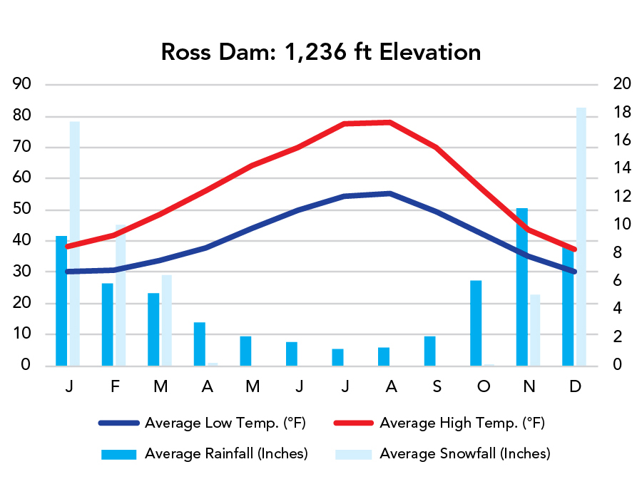
- WA-20 typically closes for winter at Ross Lake Dam.
- The park is intentionally complex. North Cascades North Unit is roadless (you can hike in from Mount Baker-Snoqualmie National Forest or Goodell Creek or Stetattle Creek or Thornton Lakes or the Beaver Trails) The South Unit can be accessed by the unpaved Cascade River Road. Most visitors only enter Ross Lake and/or Lake Chelan national recreation areas.
Highlights
- WA-20
- Cascade River Road
- Diablo Lake Overlook
- Picture Lake, Lake Ann, Ptarmigan Ridge (Mount Baker-Snoqualmie National Forest)
- Stehekin
- Ross Lake Overlook
- Gorge Creek Falls
Activities
- Hiking
- Backpacking
- Mountaineering
- Boating
- Whitewater Rafting
- Biking
- Fishing
- Cross-country Skiing
- Cross-country Skiing
Favorite Trails
Easy
Moderate- Maple Pass
- Thornton Lakes/Trapper’s Peak (scramble required)
- Blue Lake
- Diablo Lake
- Rainbow Creek
When To Go?
Weather
Visitation
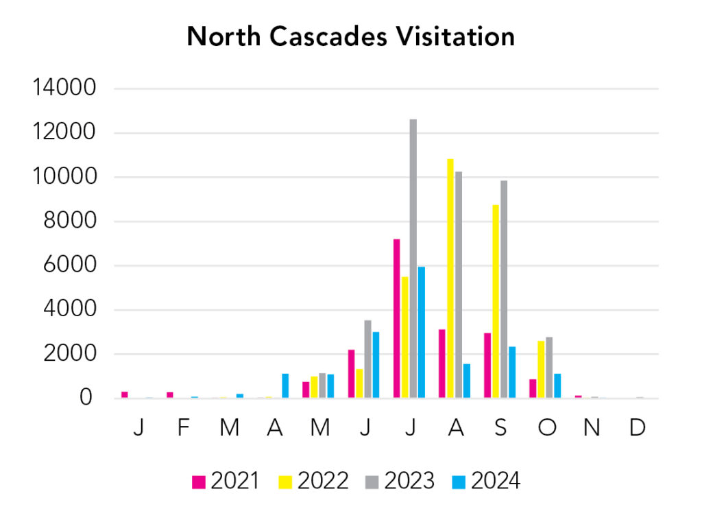
Even though elevation is relatively low along WA-20, it closes for winter at Ross Dam. Goode Mountain (South Unit) is the tallest peak in the park at 9,220 feet. And temperature drops about 3-5°F with every 1,000 feet of elevation gain. The visitation stats are misleading because they’re for the National Park (North and South units). The North Unit has no roads. The South Unit can only be accessed by the unpaved Cascade River Road. Most visitors only pass through Ross Lake National Recreation Area, which straddles WA-20. It is considered part of the North Cascades National Park Complex, which is intentionally complex and also includes Lake Chelan National Recreation Area. Together, the two national park units and two national recreation units, experience about one million visitors each year.
Park Map Downloads
Road Trips
Helpful Tools
Below you'll see a Google Map to help plan road trips from the east (Glacier), west (Olympic), and south (Mount Rainier). It’s a good start, but I’d highly recommend making your own. Google My Maps, Wanderlog, Roadtrippers, and TripIt are incredibly useful trip planning tools. Find what works best for you!
There’s much more to our country. Here’s another Google Map with points of interest across all types of public land.
For campers, here’s a Google Map with National Forest campgrounds. National Park campgrounds are difficult to reserve (there are about 200!). With nearly 5,000 national forest campgrounds, you can usually pull in and find a spot.
Highlights
- Lake Como, Trapper Peak (MT) / (Bitterroot National Forest)
- Sawtooth Lake, Finger of Fate, Grandjean (ID) / (Sawtooth NF)
- Palouse Falls SP (WA)
If you like this, please check out my books or Buy Me a Coffee (more likely some fuel 🙂