Olympic National Park
Trip Assistant
How Much Time?
There are more than a dozen disconnected regions here. Just driving to them all takes a day or two. If you want to get out and hike a little, you’ll need some more time.
Now, if you’re trying to pare things down a bit. Hurricane Ridge, Lake Crescent, Sol Duc, Hoh, and the Coast (particularly Rialto, Ruby, and Second beaches) should be your initial focus. There’s fantastic hiking at Hurricane Ridge and Sol Duc. Tidepooling at the beaches. And Lake Crescent is a pretty picturesque setting with a few good trails nearby. And, if you love trees, there are some big ones in the park and National Forest.
Need to Know
- Reservations are required for several park campgrounds.
- Being close to Seattle, a mid-week trip is a good idea.
- The vast majority of visitors arrive in summer, but Hurricane Ridge remains open for winter, and the coast is quite temperate. The bad news is winter is often wet/snowy and overcast. You’d want to plan a longer trip then, just to try and get a good weather day or two.
- There’s no ideal place for a base camp. Lake Crescent is the best you can do.
Highlights
- Hurricane Ridge
- Lake Crescent
- Rialto Beach
- Ruby Beach
- Hoh Rain Forest
- Obstruction Point Road
Activities
- Hiking
- Backpacking
- Boating
- Biking
- Swimming
Favorite Trails
Easy
Moderate Strenuous Extreme *Links to AllTrailsWhen To Go?
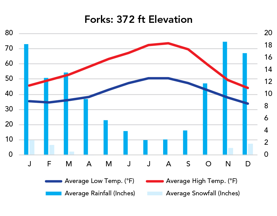
Weather
Visitation
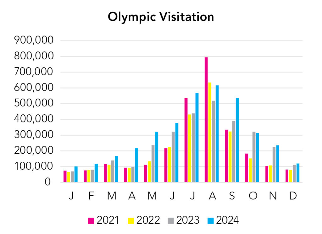
Visitation peaks in summer, when it’s driest, but that isn’t the only good time to visit. The rest of the year, you just might want to stick around longer to make sure you get a non-overcast day or two. You also have to pay attention to the elevation variance. Just because it’s nice on the beach at sea level, doesn’t mean it’ll be pleasant at 5,000+ feet elevation at Hurricane Ridge. Temperature drops about 3-5°F with every 1,000 feet of elevation gain.
Park Map Downloads
Road Trips
Helpful Tools
Below you'll see a Google Map to help plan road trips from the east (Glacier), north (North Cascades), and south (Mount Rainier). It’s a good start, but I’d highly recommend making your own. Google My Maps, Wanderlog, Roadtrippers, and TripIt are incredibly useful trip planning tools. Find what works best for you!
There’s much more to our country. Here’s another Google Map with points of interest across all types of public land.
For campers, here’s a Google Map with National Forest campgrounds. National Park campgrounds are difficult to reserve (there are about 200!). With nearly 5,000 national forest campgrounds, you can usually pull in and find a spot.
Highlights
Olympic and Mount Rainier are pretty close together. A lot of people like talking about Cape Flattery. It's nice but isolated. Put careful consideration into what the best use of your time is and how to minimize time behind a windshield. Just getting around Olympic can be a real chore, depending on the season and how many visitors are out and about.
If you like this, please check out my books or Buy Me a Coffee (more likely some fuel 🙂