Pinnacles National Park
Trip Assistant
How Much Time?
Unless you’re coming here to climb some rocks, you don’t need a whole lot of time. Doing the High Peaks Loop with Bear Gulch Cave is a half day for most. And, if it’s summer, you probably won’t want to spend a whole lot of time here anyway. It will be hot, and you’d be better off in the high elevations of Yosemite or Lassen Volcanic.
With that said, a very reasonable plan here is to arrive at the west side, get a taste of the park by hiking Balconies Cave and Juniper Canyon + Tunnel (which goes through the High Peaks). And then camp on the east side and hike Bear Gulch Cave + High Peaks in the morning.
Need to Know
- The West Entrance closes over night. The East Entrance is open 24/7.
- Caves close due to seasonal flooding and bat occupation. Check their status prior to arrival.
- Bring two light sources. A headlamp is best as it will free your hands for the little bit of crawling required.
- Shuttles used to run on the East Side on busy weekends and holidays (their status is presently up in the air).
Highlights
- High Peaks
- Bear Gulch Cave
- Balconies Cave
- California Condors
Activities
- Hiking
- Rock Climbing
- Birdwatching
Favorite Trails
Easy
Moderate Strenuous *Links to AllTrailsWhen To Go?
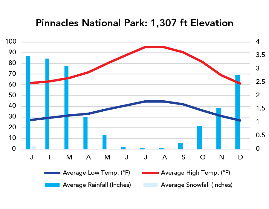
Weather
Visitation
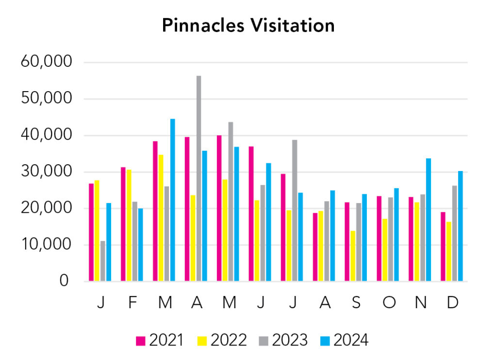
Spring break brings a visitation spike. Summer is less popular than usual due to high temperatures. It’s pretty good fall through spring.
Park Map Downloads
Road Trips
Helpful Tools
Below you'll see a Google Map to help plan road trips from the east (Sequoia), north/west (Golden Gate NRA), and west/south (McWay Falls). It’s a good start, but I’d highly recommend making your own. Google My Maps, Wanderlog, Roadtrippers, and TripIt are incredibly useful trip planning tools. Find what works best for you!
There’s much more to our country. Here’s another Google Map with points of interest across all types of public land.
For campers, here’s a Google Map with National Forest campgrounds. National Park campgrounds are difficult to reserve (there are about 200!). With nearly 5,000 national forest campgrounds, you can usually pull in and find a spot.
Highlights
- Alamere Falls (CA) (There's an unmarked path to the top of the falls just before crossing Alamere Creek) / (Point Reyes NS)
- Muir Woods NM (CA)
- Golden Gate NRA (CA)
- Shark Fin Cove (CA)
- Hole-in-the-Wall Beach (CA)
- Fern Grotto Beach (CA)
- Julia Pfeiffer Burns SP/McWay Falls (CA) - PCH 1 was closed beyond this point so you’re forced to drive out-and-back.
- Garrapata State Park (CA)
If you like this, please check out my books or Buy Me a Coffee (more likely some fuel 🙂