Yosemite National Park
Trip Assistant
How Much Time?
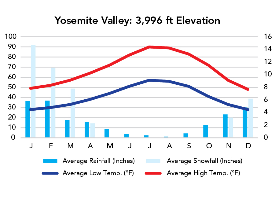
Winter is the quiet season (Yosemite Valley remains open and weather is reasonably comfortable). Spring is waterfall season. Summer is peak season (and fire season). Fall is prime hiking season, although waterfalls will be greatly diminished if not dry.
In summer, the trade-off for incomporable scenery is often overwhelming crowds and traffic. The park shuttle makes things better, but it also amplifies crowds at already popular places. The opening of Tioga Road helps ease the crush of human traffic, and, with more than 750 miles of trails, you can use your legs to get away from it all. So, how much time? If you love hiking and are willing to get up early and get after it, you cannot have too much time here. If you want to check off the essentials and move on, spend a night in the valley and carry on (maybe to the Eastern Sierra).
Need to Know
- A Timed-Entry Permit is required to drive through the park during periods of peak visitation.
- Reservations are required for camping.
- It gets very hot in Yosemite Valley in summer. It’s 15-20°F cooler along Tioga Road and in the High Sierra.
- Free shuttles simplify getting around the park.
Highlights
- Yosemite Valley
- Tunnel View
- Glacier Point
- Washburn Point
- Valley View
- Olmstead Point
- Mariposa Grove
- Hetch Hetchy
Activities
- Hiking
- Backpacking
- Rock Climbing
- Rafting
- Biking
- Horseback Riding
Favorite Trails
Easy
Moderate Strenuous Extreme *Links to AllTrailsWhen To Go?
Weather
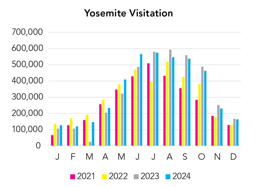
Visitation
In my opinion, summer is the worst time to be here and it isn’t the crowds. It’s hot in the valley in summer and it’s fire season. Waterfalls begin to diminish. The one saving grace is Tioga Road opening up, spreading people out, and unlocking new trailheads. But in reality, there’s no bad time to be here (unless it’s socked in with smoke). In short, spring is waterfall season. Summer is tourist season. Fall is hiking/backpacking season. Winter is quiet season (and the temps remain reasonably comfortable in the valley).
Park Map Downloads
Road Trips
Helpful Tools
Below you'll see a Google Map to help plan road trips from the east (Death Valley), north (Lassen Volcanic), west (San Francisco, CA), and south (Kings Canyon). It’s a good start, but I’d highly recommend making your own. Google My Maps, Wanderlog, Roadtrippers, and TripIt are incredibly useful trip planning tools. Find what works best for you!
There’s much more to our country. Here’s another Google Map with points of interest across all types of public land.
For campers, here’s a Google Map with National Forest campgrounds. National Park campgrounds are difficult to reserve (there are about 200!). With nearly 5,000 national forest campgrounds, you can usually pull in and find a spot.
Highlights
- Alabama Hills
- Parker Lake, June Lake Beach, Convict Lake, Big Pine Lakes), Palisades, Minarets, Whitney Portal, etc. / (Inyo National Forest)
If you like this, please check out my books or Buy Me a Coffee (more likely some fuel 🙂